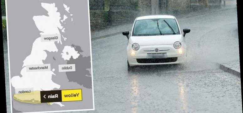
THE Met Office has issued three yellow warnings for thunderstorms and rain across many parts of the UK over the next three days.
It comes ahead of a heatwave next week which will see temperatures rocket to 28C by Wednesday and will continue into the weekend.


Heavy showers could cause flooding this evening – with possible damage to some buildings from floodwater, lightning strikes, hail or strong winds.
Torrential downpours with 25 to 35 mm rain could fall in just an hour in some places, the Met Office said.
The heavy showers and thunderstorms will slowly die out through the evening in most parts of the country.
HEAVY SHOWERS
However, they may continue across the northwest of England, southwest of Scotland and eastern Northern Ireland into the early hours of Wednesday morning.
The storm will continue tomorrow in areas around Oxford, Cambridge and Lincoln and could cause havoc for businesses and homeowners.
The Met Office said there is a small chance that homes and businesses could be flooded quickly.

Spray and sudden flooding could lead to difficult driving conditions and some road closures.
The forecasters also added some communities could experience power cuts due to the flooding.
Storms will gradually decrease by Thursday, but the south coast is expected to be hit by heavy showers which may lead to further flooding.
Met Office Chief Meteorologist Neil Armstrong said: "Although some places will miss these heavy showers and thunderstorms, where they do occur they'll be quite lively bringing torrential downpours with 25 to 35mm rain falling in an hour and a few places seeing perhaps 40 to 50mm rain in a couple of hours.


"With this heavy rain falling in a short time we could see some disruption to transport or damage to properties due to localised flooding, as well as the chance of lightning and hail."
It comes after parts of the UK were hit by heavy thunderstorms yesterday, with a yellow warning issued by the Met Office.
An Asda supermarket in Greater Manchester had to be closed due to a flooding yesterday.
FLOODING RISK
The weather is set to remain warm through the rest of this month – with temperatures still hitting 25C in large parts of the southeast region.
The Met Office weather forecast from June 30 to July 14 says that although there is a risk of showers – with some turning heavy and possibly thundery across the south – the UK should also see some drier and brighter interludes.
The forecast says: "Temperatures should generally be above average, possibly turning very warm in places.
"In early July, a transition to more settled conditions is signalled with many seeing more prolonged drier and sunnier spells.
"However, there is still the chance of showers for most at times. Temperatures likely to return back to around average."


We pay for your stories! Do you have a story for The Sun Online news team? Email us at [email protected] or call 0207 782 4368.
Source: Read Full Article