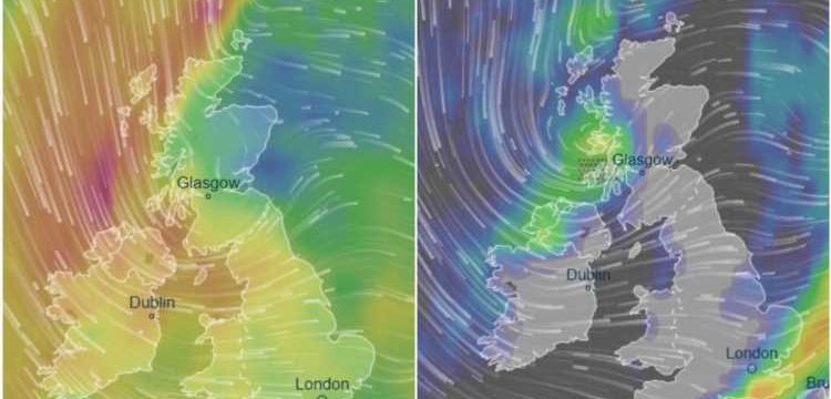
BRITAIN is bracing for 60mph gales in parts today as the summer gives way to autumnal winds and a severe dip in temperatures.
Met Office weather experts also warn of torrential rain in parts – especially across the already-soaked northwest on Wednesday.


In its latest forecast, the Met Office said: "Heavy showers and gales in Scotland, Northern Ireland and northwest England through the day.
"Rain in southeast England to begin with, then clearing.
"Elsewhere, often windy with sunny spells and scattered showers, perhaps heavy."
Temperatures in parts will hold up in the mid-to-high teens on Wednesday – and may even hit 21C in the southeast.
But these figures will quickly tumble through this week as the typical September weather bites.
SPONSORED CONTENT: How to save £219 a year off your energy bills
BEAT energy price rises year after year with Switchcraft. It's free and it could save you an average of £219 a year.
- Sign up, easily compare tariffs and switch
- Once you sign up, Switchcraft will automatically find you a cheaper deal when a better tariff comes up, saving you time, hassle and money.
- It takes just 3 minutes. That's it!
- Get £5 cashback and never worry about switching again
- Click here to get saving!
News UK has a brand partnership with Switchcraft. The £5 will be paid into your bank account within four months of completing the switch. Prepayment meter customer customers will receive a £5 Amazon voucher. Open to those 18 and over. UK residents only. Click here for full T&Cs.
As the days progress this week, high temperatures will only muster around 17C by Friday – with a slight improvement to 18C at the weekend.
On today's outlook, Met Office forecaster Aidan McGivern said: "Sunshine replaces the rain and then it's a fine day for southern England as well as much of Wales.
"But for Scotland, Norther Ireland and the far north of England outbreaks of rain or showers continue to tumble in along with an increasingly brisk wind for the north and west of Scotland and Northern Ireland.
"There will be gaps in between the rain though there will be some sunshine."
By Wednesday evening, the gale-force winds will be the main weather feature – with 55-60mph possible in some areas.
It comes as Met Office figures revealed the three months from June to August were Britain’s 12th warmest since records began in 1910.
But while hot summers tend to be drier, this summer was the seventh wettest recorded for the UK as a whole.
Tim Legg, of the Met Office’s National Climate Information Centre, said: “The picture for each of the three months was different depending on where you were in the UK.
“Southern England and Wales endured the heaviest rainfall in June, whereas Scotland and northernmost parts of England saw the heaviest rainfall in August.”


Source: Read Full Article