HURRICANE Lorenzo, the strongest storm ever to make it so far east and is causing problems for commuters in South Wales and the south-west of England.
Here's what you need to know about its likely impact.

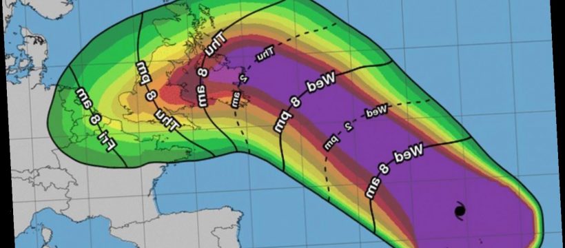
What’s the latest on Lorenzo?
Hurricane Lorenzo at one point reached wind speeds of 160 mph as it made its way across the Atlantic.
The US National Hurricane Centre (NHC) says it is "the strongest hurricane east of 45 degrees west longitude in the Atlantic on record".
Its quick growth was also rare for Atlantic hurricanes, which usually gain intensity further west.
Lorenzo was reclassified as a Category 5 Hurricane on Sunday, September 29.
While it has now been downgraded to a storm it is still strong enough to cause problems.

When will it hit the UK?
The tail end of the 500-mile-wide storm which it dubbed a "real beast" reached parts of the UK yesterday, October 3.
Irish weather forecasters Met Eireann said the storm would make landfall on the western coast of Ireland at around midnight tonight, October 3.
Met Eireann warned that mean wind speeds could reach 50mph with gusts peaking at 80mph.
The Met Office issued a yellow weather warnings for wind in Northern Ireland for Thursday and South West England and Wales on Friday.
It warned early-morning commuters to "watch out" for strong winds, possibly getting up to 65mph, in those areas and there could be rain in many parts as well.
There are currently eight flood warnings in place in England and another 34 flood alerts in place.
The Environment Agency has warned of flooding in the north-west and Midlands as well as south-west and north-east Wales.
Five counties in Ireland have been issued with Status Orange wind warnings with coastal areas braced for flooding.
Dublin Airport remains open with both Ryanair and Aer Lingus saying they planned to operate a full flight schedule but added some cancellations and delays may be necessary.
Passengers were urged to check before arriving at the airport.
Northern Ireland and England's south-west could see wind speeds reaching 60mph with waves hitting 18ft.
The Irish coast guard has warned people to stay away from cliffs and the sea.

The Environment Agency warned: “Flooding from surface water and rivers is possible across Wales, the Midlands and North.
"Coastal or tidal flooding is possible on coasts of south Wales and south-west England.”
Met Office forecaster Steven Keates said: “Lorenzo is a real beast of a storm.
"It will be one of Europe's strongest ever tropical storms, as the Azores are part of Europe.
“After reaching the Azores on Tuesday, Lorenzo is expected to move to the UK by Thursday – bringing a couple of days with potentially worse conditions than this weekend.

“There are scenarios from gales to storm-force 70mph-plus gusts, but there's uncertainty.
“Big waves and heavy rain are likely, with the west most likely to be affected.
“Before then, five or six inches' rain will fall between Saturday and Tuesday in the wettest places.”
Parts of England are expected to be battered by gale-force winds reaching 60mph later today, whipping up 30ft waves.
Heavy rain is also on its way today with Northern Ireland expected to see around 20-30mm of rain.
A Met Office weather forecaster said on Thursday, October 3: “Lorenzo will also bring a spell of heavy rain to much of the UK mainly today into Friday.
“Keep an eye out for any warnings which may be issued in your area.”
They added: “Warnings have been issued so people should stay weather-aware.”
Source: Read Full Article