Britain was blasted by 65mph winds today on potentially the COLDEST ever Bank Holiday Monday – as an arctic freeze is set to hit next week.
The 800 mile-wide 'weather bomb' was shown on a weather map with Netweather TV warning: "Mayday! Mayday!"
Rain will fall from late morning until night for most throughout the UK.
And there will be sleet and snow on higher ground in the north, according to The Weather Outlook.
Temperatures will struggle to reach above 12C today, with many areas significantly below.
Brutal winds will push 70mph in some areas, with the Met Office forecasting 65mph gusts near coasts in the south and up to 50mph in the north.
The extra day off has been declared a "total washout" – and the wintry conditions look likely to continue for the rest of the week.
Read all the latest weather news and updates in our live blog below…
- Joseph Gamp
BRITS WARNED OF ‘TOXIC BUG’ EXPLOSION
Brits have been warned about toxic bugs as the mild winter and spring weather will bring a population explosion this year.
Oak processionary moths lay their eggs from late April and infest trees once hatched.
They can be poisonous to humans if they come directly into contact with the skin.
The bugs have been blamed for causing breathing problems, which have been fatal – but not in the UK.
Forestry England warned the caterpillars have black heads and bodies covered in long white hairs which contain proteins which can cause itchy rashes, eye, and throat irritations.
- Joseph Gamp
HAPPY MAY! OR IS IT?
Happy May, a happy new month that is one step closer to summer.
But forecasts suggest it may feel more like Siberia than the Bahamas – as freezing air is being pushed in from the Arctic.
The new month is expected to bring some more frost, rain, and wind.
- Joseph Gamp
'DRASTIC CHANGE IN WEATHER DURING FIRST WEEK OF MAY' – BBC WEATHER
The first week of May will see a “drastic change in the weather for the UK from the second half of April”, says BBC Weather.
It adds: “As high pressure – a frequent visitor in recent weeks – shifts away to the south, low pressure weather systems will push in from the west and make for an unsettled week with some episodes of heavy rain and stronger winds.”


- Joseph Gamp
STARK-NAKED NATURISTS TO STRIP OFF FOR BAY STROLL
One hundred naturists will make history this summer as the first to trek four hours NAKED across treacherous Morecambe Bay.
British Naturism members plan to disrobe to cross the dangerous Lancashire estuary in aid of the British Heart Foundation.
They will begin and end the walk, which involves knee-high sea wading, on June 20 fully-clothed – before stripping off when away from the coastline.
They will be accompanied by Michael Wilson, the Queen’s Guide to the Sands, who will not be expected to undress.
Ron O’Hare, British Naturism’s campaigns secretary, said: “We will be permitting clothes if walkers feel cold.”
- Joseph Gamp
MET OFFICE YELLOW WEATHER WARNING FOR WIND
The Met Office has issued a yellow weather warning for wind for Monday and Tuesday.
It warns: “A vigorous area of low pressure is likely to cross Northern England on Monday.
“Strong winds are expected to the south of the low centre with gusts widely 40 to 50 mph, but perhaps as high as 60 mph around some coasts and hills of England and South Wales.
“The winds should gradually ease through Tuesday morning. The strong winds will be accompanied by some heavy rain at times.”
- Joseph Gamp
WIND WARNING: AFFECTED REGIONS
A spell of disruptive winds is likely from Monday afternoon and into Tuesday morning.
The affected regions are:
- East of England
- London & South East England
- South West England
- Wales
MET OFFICE FORECAST MONDAY TO WEDNESDAY
A bright start, but becoming wet and windy for most Monday.
Strongest winds in the south.
A return to sunshine and showers from Tuesday.
Remaining chilly with some night frost.
MET OFFICE’S FORECAST FOR MAY 6 TO MAY 15
Unsettled conditions to start the period, especially in the south. Generally looking at sunny spells interspersed with showers across the UK.
The showers may become longer spells of rain at times, and are expected to be wintry across Scottish hills. The best of the sunshine is expected in sheltered central spots.
Often windy, with occasional gales possible in the far north/northeast. Temperatures colder than normal for most, especially in the north.
Towards the end of the period, uncertainty increases, as is typical of spring. It is largely expected to remain unsettled, though spells of fine, dry weather will become possible, especially at the very end of the period.
Temperatures likely to start trending higher, but it is unlikely to become unseasonably warm.
BBC WEATHER: ‘WETTEST AND WINDIEST START TO THE WEEK’
BBC Weather said it will be the “wettest and windiest to start the week and not too much drier later on”
Forecasters added: “Is there anything more spring-like on the way?”
- Joseph Gamp
COLDEST UK MAY TEMPERATURE EVER RECORDED
It was another cold and frosty start for many today, with Tyndrum in Scotland falling to -4.2C.
But the Met Office has revealed that the coldest temperature in May in the UK was -9.4C.
It was recorded twice at Lynford in Norfolk on the May 4 and 9 in 1941.
- Joseph Gamp
BANK HOLIDAY MONDAY SAY AN 800-MILE 'WEATHER BOMB' STORM HIT
A 70mph Atlantic ‘weather bomb’ storm will bring an all-day deluge on potentially the coldest ever May Bank Holiday Monday.
The 800mile-wide torment was shown on a weather map as Netweather TV tweeted: “Mayday! Mayday!”
- Joseph Gamp
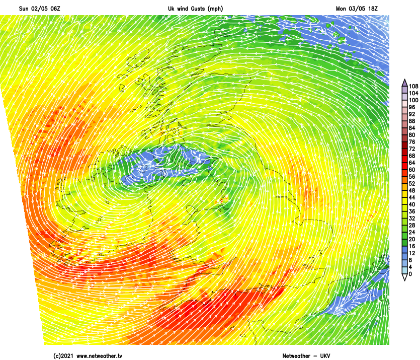
MAPPED: BANK HOLIDAY MONDAY WIND GUST SPEEDS
The strongest winds today affected Wales, coastal areas of southern and perhaps also northwest England, along with coastal regions of much of Ireland.
Gusts reached between reach 60 to 70mph, particularly in exposed spots.
Here's a map released by NetWeather showing wind gusts.
- Joseph Gamp
MAY 2021 COULD BE WETTEST SINCE RECORDS BEGAN
Bookmaker Coral has slashed the odds on this May being the wettest since records began to just 5-4 as the UK gets drenched over the Bank Holiday.
“We think it could be the beginning of our wettest May ever. We’ve slashed the odds on it happening,” said Coral’s Harry Aitkenhead.
- Joseph Gamp
BOOKMAKER SLASHES ODDS ON MAY SNOWFALL
Bookmakers have slashed the odds on snow falling in the UK in May to 2-1 (from 8-1) as average temperatures for this time of the year are much lower.
Coral Bookmakers makes it 6-4 for this month to end as the coldest May on record, while it is 5-4 for a record wet month.
“The start of May normally arrives with glorious sunshine and rising temperatures. According to the latest betting. this year there is a strong chance we could get some snow fall in parts of the UK,” said Coral’s John Hill.
“With more rain on its way later in the week, the odds have also been cut on this month ending as the wettest May on record. Roll on June!” added Hill.
- Joseph Gamp
MET OFFICE – ‘WEATHER GRIM READING' (CONTINUED…)
Day-time temperatures are expected to fall well below the 16C average for this time of year and will plummet by night.
Met Office forecaster Simon Partridge said: “At the moment there’s no end in sight.
“There’s nothing too promising until mid-May when things start to settle down again.”
Last month was the frostiest April on record and the coldest since 1922. It also saw snow and -10C temperatures.
- Joseph Gamp
MAY RAIN 'MAKES WEATHER GRIM READING’ SAYS MET OFFICE FORECASTER
Met Office forecaster Simon Partridge said: “We’ve just gone through one of the driest April’s on record so maybe this [rain] will even things up.
“The rain will probably be a welcome relief for Britain’s farmers and growers but for the rest of us it’s pretty grim reading.
“As it stands this week is a write-off. After a wet and windy Bank Holiday Monday colder air will arrive from the north.
“It’s going to be a chilly week with even more frosts on the way.
“If that wasn’t bad enough, by the time we get to the weekend we’re going to see more unsettled weather.”
- Joseph Gamp
FURTHER ODDS SLASHED ON WETTEST MAY ON RECORD
Ladbrokes has slashed odds on this May being the wettest on record.
With Britain set to be battered by heavy storms, the bookies have cut odds from 3/1 to just 5/2 on this going down as the wettest May ever.
Alex Apati of Ladbrokes said: “It’s looking increasingly likely this could go down as a record-breaking wet May if the latest odds are anything to go by.”
- Joseph Gamp
COLDEST MAY BANK HOLIDAY EVER
Today is the UK’s Coldest May Bank Holiday EVER after the mercury plummeted to a chilly -5.9C this morning.
Meanwhile snowfall, heavy rain and 70mph gales are expected to hit later today.
The extra day off has been declared a “total washout” – and the wintry conditions look likely to continue for the rest of the week.
This morning’s freezing -5.9C was recorded at Kinbrace in the Scottish Highlands.
That made it exactly as cold as it was this time in 2012 – which was the coldest on record.
- Joseph Gamp
YELLOW WIND WARNINGS IN PLACE UNTIL TUESDAY MORNING – MET OFFICE
“Disruptive” gale force winds is to batter the UK’s south until Tuesday morning, warns the Met Office.
It said Brits could expect delays to road, rail, air and ferry transport.
There could be damage to outdoor temporary structures, with some tree branches down too.
“It’s likely that some coastal routes, sea fronts and coastal communities will be affected by spray and/or large waves,” the agency adds.
- Joseph Gamp
WATCH: TORNADOES RIP THROUGH MISSISSIPPI IN 'LIFE-THREATENING SITUATION' LEAVING BUILDINGS DESTROYED AND POWER LINES DOWN
Tornadoes rip through Mississippi in ‘life-threatening situation’ leaving buildings destroyed and power lines down
- Joseph Gamp
THERE COULD BE SUNSHINE ON TUESDAY!
The UK “will be back to the sunshine and showers on Tuesday, blown-in on blustery, chilly winds,” reports Netweather TV.
The forecasters add: “If you’re wondering about any signs of some summery weather, it’s not looking great at the moment.
“Temperatures [are] looking likely to stay below average through the first couple of weeks of May, albeit with some indications they may be starting to recover towards mid-month.
“It’s Spring, though, which is one of the more unpredictable times of the year, so plenty of scope for changes to the forecast beyond five-to-seven days.”
- Joseph Gamp
MET OFFICE: LONG RANGE FORECAST FOR MAY 6 – 15
Unsettled conditions to start the period, especially in the south. Generally looking at sunny spells interspersed with showers across the UK.
The showers may become longer spells of rain at times, and are expected to be wintry across Scottish hills. The best of the sunshine is expected in sheltered central spots.
Often windy, with occasional gales possible in the far north/northeast. Temperatures colder than normal for most, especially in the north.
Towards the end of the period, uncertainty increases, as is typical of spring. It is largely expected to remain unsettled, though spells of fine, dry weather will become possible, especially at the very end of the period.
Temperatures likely to start trending higher, but it is unlikely to become unseasonably warm.
- Joseph Gamp
WINDS OF 76MPH PUMMELLED WALES TODAY
Capel Curig in North Wales has today been pummelled by a “gust of 76 mph” reports the Met Office.
It’s tweeted the latest view of a cloud-covered UK from a satellite.
The agency added: “Here’s something we’ve not seen for a while, a deep area of low pressure bringing useful but perhaps rather ill-timed rain to many places this Bank Holiday Monday.”
- Joseph Gamp
BOOKMAKER SLASHES ODDS ON MAY SNOWFALL
Bookmakers have slashed the odds on snow falling in the UK in May to 2-1 (from 8-1) as average temperatures for this time of the year are much lower.
Coral Bookmakers makes it 6-4 for this month to end as the coldest May on record, while it is 5-4 for a record wet month.
“The start of May normally arrives with glorious sunshine and rising temperatures. According to the latest betting. this year there is a strong chance we could get some snow fall in parts of the UK,” said Coral’s John Hill.
“With more rain on its way later in the week, the odds have also been cut on this month ending as the wettest May on record. Roll on June!” added Hill.
- Joseph Gamp
MET OFFICE TWEET'S THIS EVENING'S WEATHER
Source: Read Full Article